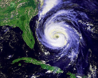

The United States has been hit by some intense hurricanes over the years that have caused a great deal of destruction and deaths. What exactly does worst mean, since there are different ways to classify a hurricane as the worst? By dollar amount of damage, by death toll, by area coverage size, the highest wind speed, storm surge or lowest barometric reading. Here are the most intense and worst hurricanes in U.S. History.
Usually the lower the barometer, the more intense the hurricane is. These are the stories of the hurricanes with the lowest barometric pressure at the time of landfall. When you read these barometric pressures, look at your home barometer and see just how low they are.
The Labor Day Hurricane – 1935
The tropical depression was first noticed just east of the Bahamas on August 29, 1935 and became a hurricane September 1. Moving to the west-northwest, the hurricane rapidly strengthened into a category 5 hurricane; the most intense category.
When the Labor Day Hurricane hit the Florida Keys on September 2nd between Key West and Miami, it became the first category 5 hurricane ever to hit the US.
The winds have been estimated between 150 and 200 mph with higher gusts. The official barometric reading is listed at 26.35 inches of mercury (892 mb) at Long Key, Florida.
This is the lowest barometric pressure reading and the most intense hurricane to ever hit the US. The storm killed 408 people, many of which were World War I veterans working in the Keys. An evacuation train was sent before the storm but never made it.
Hurricane Camille – 1969
Continuing on this path and still gaining strength, it hit the Mississippi coastline on August 17th at Bay St. Louis as a category 5 with a barometric pressure of 26.84 inches (910 mb), making Camille the second most intense hurricane to hit the US.
Hurricane Camille had winds of 200 mph and a storm surge of 24.6 feet at Pass Christian, Mississippi along with 10 inches of rain causing 143 deaths along the Gulf Coast.
But this wasn’t the end of Camille, as it traveled through the US it dropped huge amounts of rain along the way. When Camille reached Virginia it produced between 12 and 31 inches of rain that caused devastating flash floods and an additional 113 deaths in Virginia.
Hurricane Michael - 2018
Hurricane Michael made landfall near Mexico Beach, Florida as a category 5 hurricane. Michael was the first category 5 storm since Andrew and only the fourth category 5 to ever hit the United States.
When it made landfall, the barometric reading was 919 mb (27.14 inches), and the winds were measured at 160 mph.
At first, it was believed that the hurricane was a category 4 when it made landfall, but further analysis determined it was a category 5.
The storm caused 16 deaths and $25 billion in damages along the Florida panhandle. There was massive damage in towns from Mexico Beach to Panama City. The storm then moved into the Carolinas causing major flooding.
Hurricane Katrina - 2005

Katrina might be the most talked about hurricane in US history because of the poor preparation and lack of government help at all levels after the hurricane. Katrina became a worst case scenario for New Orleans killing 1,200 people and the deadliest hurricane to hit the US since the 1928 Lake Okeechobee hurricane.
Katrina first became a tropical storm on August 24th and became a hurricane on the 25th right before it made landfall near Miami, Florida. Katrina quickly moved west across Florida and into the Gulf of Mexico where it rapidly regained strength.
By August 28th, 195 miles southeast of New Orleans, Katrina became a category 5 hurricane with winds of 175 mph and a central pressure of 26.64 inches (902 mb). Katrina moved north-northwest losing some strength before landfall at Buras, Louisiana on August 29th as a strong category 3 hurricane.
At the time of landfall, the central pressure of Katrina was 27.17 inches (920 mb), making Katrina the third most intense hurricane in US history at the time of landfall.
The storm surge was almost 28 feet on the east side of Katrina at Pass Christian, Mississippi where many buildings were destroyed.
There was also a storm surge on Lake Pontchartrain to the west of the eye of the hurricane; in the eastern part of New Orleans the surge was 19 feet which caused the levees to overflow and flood sections of New Orleans.
 |
| Gulfport, Mississippi after Hurricane Katrina |
Hurricane Andrew – 1992
Out in the Atlantic Ocean, Andrew became the first named tropical storm of 1992 on August 17th. After moving south of the Lesser Antilles in unfavorable weather conditions for hurricane development, Andrew almost dissipated.
Moving in a westerly direction and still holding together, Andrew finally became a minimal hurricane on August 22nd and in just 36 hours had reached a strong category 4. The eye of Hurricane Andrew passed over the Bahamas and continued onward to South Florida.
Weather conditions were possible for further deepening of the storm as it approached Florida.
At 5 AM on August 22nd, Hurricane Andrew made landfall at Homestead, Florida just south of Miami with winds estimated at 145 mph with gusts to 175 mph and a barometer reading of 27.23 inches (922 mb) though some weather spotters saw lower readings.
Homestead Air Force Base was practically destroyed as was the town. Andrew crossed southern Florida in four hours and entered the Gulf of Mexico where it continued on a northwest track until another landfall in Louisiana on August 26th as a category 3 hurricane. Andrew killed 23 people in the US.
 |
| Homestead AFB after Hurricane Andrew |
Indianola, Texas - 1886
Indianola, Texas was an important port city on the Gulf of Mexico north of Corpus Christi when on August 20, 1886 it was destroyed by one of the most intense hurricanes in US history.
The hurricane hit Cuba as a category 2 storm on August 13th and continued to move northwest into the Gulf. The storm rapidly gained strength as it neared the Texas coast.
When the storm made landfall on August 20th, it had an estimated 155 mph winds and a barometric reading of 27.31 inches (925 mb) with a storm surge of 15 feet.
Indianola was never rebuilt after this storm. Galveston then became the major Texas port city until it was destroyed by the 1900 Galveston Hurricane.
The Next Five Most Intense Hurricanes
- Florida Keys/South Texas – 1919: This hurricane went through the Dry Tortugas where a ship recorded the pressure at 27.37 inches (927 mb). The hurricane continued into the Gulf of Mexico striking Corpus Christi, Texas with a storm surge of 12 feet, causing an estimated 900 deaths, with 500 of these deaths on 10 ships that were sunk or lost. The storm was not as strong when it struck Texas as it was in the Florida Keys. When the storm made landfall in South Texas on September 14th, the barometric pressure was reported to be 28.05 inches (950 mb) with winds to 115 mph.
- Lake Okeechobee Hurricane – 1928: The storm struck Palm Beach, Florida on September 16th with a barometric pressure of 27.43 inches (929 mb). The worst part of this storm actually occurred further inland at Lake Okeechobee where a storm surge of 9 feet flooded the area killing 1,836 people.
- Hurricane Donna – 1961: On September 10th, Donna hit the Florida Keys as a category 4 hurricane with a barometric pressure of 27.46 inches (930 mb). Donna moved north just offshore paralleling the coast and was still a hurricane until it reached northern Maine three days later.
- Carla 1961: Made landfall at Port Lavaca, Texas on September 11th with a barometric pressure of 27.49 (931 mb), winds to 170 mph and a storm surge of 22 feet. Carla is the most severe hurricane to ever hit the US according to the Hurricane Severity Index. There were only 46 deaths because of a massive evacuation before the storm. Carla also had one of the worst tornado outbreaks of any hurricane.
- New Orleans 1915: Barometer of 27.49 (931 mb).
- Hugo 1989: Hit Charleston, South Carolina on September 22 and had a minimum barometric pressure of 27.58 (934 mb).
Conclusion
There have been so many devastating hurricanes that have hit the US it is hard to just write about these ten with the lowest barometric pressure.
© August 2010 Sam Montana


No comments:
Post a Comment