Colorado has several distinct areas, each with their own type of weather. The western slope is usually milder and the Rocky Mountains have their share of wild weather and being so high, they influence much of the weather in eastern Colorado. The High Plains of eastern Colorado is where most of the wild weather occurs, including the city of Denver.
Eastern Colorado has four distinct seasons, but it can change in an instant. Colorado's wild weather can change from a beautiful fall day to a howling blizzard in just a couple of hours.
You really have to respect and love weather to have enjoyed the following wild weather events of Colorado.
No one likes the damage or injuries that wild weather can bring with it, but being able to enjoy the awe and beauty of weather is what makes living in Colorado, where wild weather is more normal than abnormal, great.
Arctic Cold Fronts in Colorado
 |
| Cold front |
In the Texas Panhandle, they have a saying that there is nothing between them and the Arctic Circle except a barbed wire fence. That saying is also accurate for the High Plains of Eastern Colorado.
The following picture is an Arctic cold front as it moves through eastern Colorado as seen from a jetliner flying from Los Angeles to Chicago while over Colorado.
 |
| Photo by Amanda Wicks |
A cold front from the north usually causes blowing dust and the temperature to drop 10 or more degrees in minutes. A cold front like this is not unusual in Eastern Colorado, but there are a few that are more dramatic than others.
On January, 15, 1982, a cold front came through Denver and dropped the temperature from 39 degrees to 17 degrees in less than an hour with blowing dust and a few snow flurries.
Once in a while, when an Arctic cold front blows in like this, it can start snowing shortly after, even if the temperature had been well above freezing before the cold front.
The afternoon of January 25, 1980 was pleasant and sunny with the temperature in the 40s. I remember working in the yard that afternoon without a jacket.
A cold front blew through with bitterly cold temperatures, winds of over 50 mph and snow. Within an hour, during the evening rush hour, the temperature had dropped into the teens, a wind chill well below zero and the snow blowing horizontally.
Within a few hours, hundreds of rush hour motorists were stranded on Denver highways.
Chinook Wind Storms
 |
| Damage in Boulder, Colorado from Chinook wind storm / NCAR |
Chinook winds are down slope winds that occur on the eastern slope of the Rocky Mountains of the front range of Colorado. They are welcome during the winter as they can raise the temperature into the 50s and warmer.
A Chinook windstorm is caused when there is a large barometric pressure difference between the western slope of the Rocky Mountains and the eastern slope.
The Chinook windstorm can be enhanced if the jet stream is in the right position. Chinook windstorms can cause major damage to cars, homes and businesses.
Other than tornadoes, Chinook winds create the highest wind speeds in Colorado. One of the worst Chinook windstorms occurred January 11-12, 1972. The high winds started blowing during the afternoon and through the night.
By the next morning, more than 25 mobile homes were destroyed and many homes had their roofs blown off. One business had three walls collapse when its roof blew off.
Cars traveling on U.S. 36 (The Boulder Turnpike) between Denver and Boulder had their paint sandblasted off by the high winds and some even had their windows blown out.
I remember the wind blowing so hard that day, sand was blowing in through tiny gaps of the window frames at school and the dining room chandelier swaying back and forth at home.
This particular Chinook windstorm registered one of the highest wind speed ever recorded in Colorado.
The National Center for Atmospheric Research (NCAR) building in Boulder recorded a wind gust of 144 mph (232 km/h). Wind speeds between 90 mph and 110 mph were common throughout the area.
Another Chinook windstorm in 1982 had a peak gust of 147 mph at NCAR and 20 wind gusts over 120 mph. More than 40% of all buildings in Boulder had damage.
Wild Temperature Changes
Arctic cold fronts and Chinook winds can combine to create wild temperature swings in Colorado. One of the most impressive temperature changes happened on February 7-8, 1936.
On the morning of the 7th, the temperature was 39 degrees when an Arctic cold front blew in.
Within an hour, the temperature had dropped to 1 degree above zero.
By 6 AM the next morning, a record low temperature had reached -25F. During the day, the Chinook winds had started to blow and by afternoon, the temperature was up to 35 degrees for a temperature rise of 60 degrees in 13 hours.
One wild temperature change I do remember happened in February 1989. This was one of the worst cold waves of the century and was nicknamed the Alaska Blaster.
The temperature stayed below zero for 69 straight hours in Denver with wind chills as low as 50 degrees below zero.
The last morning of the Alaska Blaster was -30 at my house and then the Chinook winds started to blow. By noon, the snow and ice was melting off of the roofs and sidewalks.
Hailstorms
 |
| Thunderstorm over Denver by Brian Papantonia/Flickr |
Eastern Colorado is in an area known as Hail Alley and for a good reason. Hailstorms can be destructive and fascinating all at the same time.
This continues until the hailstone is too heavy for the updrafts and falls to the ground. You can cut open a hailstone and count the rings; this tells you how many times it went for a ride in the thunderstorm cloud.
On July 11, 1990, one of the worst hailstorms in U.S. history hit the front range of Colorado with hail as large as baseballs. Nicknamed the 7-11 storm, the hailstorm caused 605 million dollars in damage with many injuries.
This was the first and only time I have ever seen baseball size hail and it was something to see and hear. In parts of Denver, every car you passed or saw parked had broken windows. And greenhouses were just frames without glass.
An interesting occurrence can happen after a hailstorm, and that is dense fog. A much more localized severe hailstorm happened in June 1963. I remember that it was hot and humid before the storm and the storm clouds were as black as I have ever seen.
During the hailstorm, the wind was so strong and the hail so intense, that the hail was piling up in drifts and filling up the basement window wells.
After the storm, the hail had cooled the air and ground so much, that dense fog formed. The fog was so thick, you couldn’t see 100 feet. This particular hailstorm was so intense, that photos from it were featured in Life Magazine.
Colorado Blizzards
 |
| 1982 Christmas Eve blizzard in Denver |
By early afternoon, the blizzard had become so severe that businesses, malls and most roads had been closed. Shoppers found themselves stranded at malls where they had to spend Christmas Eve and much of Christmas Day.
The Denver airport was closed for 33 hours and all roads and railroads were closed in and out of the city. Those lucky enough to be at home could only go out on foot, skis or snowmobiles.
People still had to go to the store on Christmas Eve and as I recall, I was the one elected to go to the store for eggnog and other "refreshments". Walking to the store was not easy as the snow was up to my waist and the drifts higher.
The Rainbow After the Storm
 |
| Rainbow over Denver |
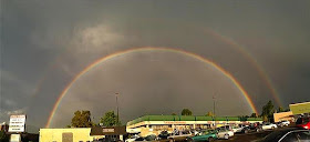
There are vivid lightning storms, torrential rains and tornadoes in Colorado, and there is usually a rainbow after the storm. On June 15, 1988, several tornadoes touched down in Denver.
By the end of the storm, three tornadoes had touched down in the Denver area that day and did quite a lot of damage. Once the storm moved east and the sun came out, a double rainbow appeared.
You can also see rainbows during the winter in Colorado. A snow shower or ice crystals with the sun shining can also create beautiful rainbows.
Copyright © 2014-2022 Sam Montana


Thank you so much for this post . This is really helpful.
ReplyDelete